The Platform
The GeoIKP provides information, data, and assessment tools for Nature-based Solutions. It is a product of the H2020 OPERANDUM project on NBS addressing hydro-meteorological hazards under current and future climate conditions. Therefore, the platform’s content is partly based on the outcomes of the project.
Here, is the link to the platform: http://geoikp.operandum-project.eu/
Getting Started
Are you a citizen eager to learn about Nature-based Solutions and find the right solution for your challenge, a scientist spatially analyzing Nature-based Solutions and their effectiveness, a policy-maker looking for gaps in policies for Nature-based Solutions, a company searching for Nature-based Solutions related data for your project, an association wanting to know more about the (co-)benefits of Nature-based Solutions, or a journalist reporting on existing Nature-based Solutions around the world?
The GeoIKP platform is designed to meet your needs! Select your profile on the website and start finding answers to your questions! Below, you can open the right user guide helping you make use of the platform’s full potential.
Citizen
Any person living in the proximity of the OPERANDUM Open-air Laboratories or Nature-based Solutions, directly or indirectly impacted or having an influence on the functioning of those.
To the user guide:

Scientist
Universities and research organizations engaged in research and development and training of individuals and/or organizations.
To the user guide:

Policy-maker
Supranational, national and local government; intergovernmental and multilateral organizations. Public and semi-public entities/authorities that have interest in OPERANDUM related topics.
To the user guide:

Business & Investors
Privately owned profit-orientated business and industrial groups.
To the user guide:

Association
Associations of categories, organizations, interest group.
To the user guide:

News & Media
Any other stakeholder that might use the platform to acquire information about the project or Nature-based Solutions, including social media and news outlets.
To the user guide:
Note: You can use the platform without registering. However, some functionalities are only available for registered users.
Help us improve the platform and the user guides!
Comment on the user guide:
Select the section you want to comment on in the user guide.
Click comment and let us know what we can improve.
Report an issue you found in the platform:
Send us an email: info[at]kajoservices.com
Technical Information
GeoIKP modules
GeoIKP is a web application that includes three modules:

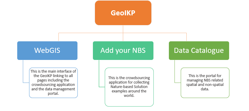
WebGIS Module
The WebGIS represents the main interface of the platform and links to the other two modules (Crowdsourcing and Data Management Module). Each user profile has access to the fundamental tools (NBS, policy and data catalogues, an interactive map and an NBS toolkit) and informative pages (about NBS, OPERANDUM case studies in detail and their permitting paths) in the context of Nature-based Solutions.
Link to the module: GeoIKP Platform
Crowdsourcing Module
Crowdsourcing module functions as a tool for collecting NBS case studies targeting primarily the reduction of hydrometeorological hazards. The tool can be accessed via the WebGIS from the top menu: Add your NBS.
Link to the module: Add your NBS
Data Management Module
The data catalogue functions as a hub allowing storing, publishing, and sharing of NBS related data. The platform was developed with the open software CKAN targeting the collection of harmonized metadata aligned to international standards and the INSPIRE Directive. Furthermore, the platform allows the upload of any type of data ranging from PDF and JPEG to spatial and observational data.
Link to the module: Data Catalogue
Versions
Since the beginning of OPERANDUM project, GeoIKP has been updated several times. In the following table, major updates of GeoIKP are listed.
Version | Main features | Completed date |
|---|---|---|
1.0 | Initial version with a basic set of functionalities | |
2.0 | Redesign of the platform, user customization with new functionalities | |
3.0 | Visual re-design, new interface for adding/editing/reviewing NBS case studies |
|
4.0 | Improvement and finalisation of tools, visual redesign, bug fixing |
|
Along with updates of the platform, the user guides were updated as well:
Version | Main features | |
|---|---|---|
1.0 | Separate user guides for the three GeoIKP modules |
|
2.0 | Merged user guides for tailored to each of six user profiles |
|
3.0 | Online user guide |
|
4.0 | Updated online user guide |
|